 |
NEWSLETTER CONTENT
1. GeoNeurale Courses Program 2008
2. Two for One (by Gene Ballay)
3. Bibliograpy5. Determinismus and / or Artificial Intelligence for Pattern Recognition?
Artificial Intelligence Methods for Pattern Completion and Interpretation,
AI Methods for Applications in the field of Geosciences
(by Hansruedi Frueh)
6. Carbonate Petrophysics Consulting
7. References and Links
TWO FOR ONE
2 for 1 or 1 + 1 = 3
by R.E. (Gene) Ballay PhD
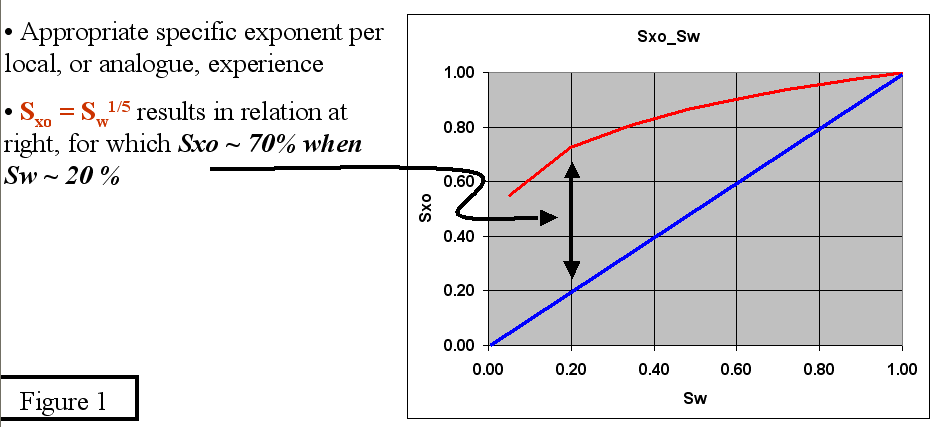
| Abstract A routine suite of open hole logs, that includes both porosity and resistivity, has the potential to provide not one, but two, independent evaluations of the formation. When a full suite of OH logs are available, one typically estimates Sw according to Sw n = a R w / ( Phi m R t) In a newly drilled area � a , Rw and m " may not be well known. And if pore geometry is possibly changing (such as in a carbonate, vuggy <-> intergranular / intercrystalline), the associated variable �m" presents an additional challenge in even well-drilled fields. If a water leg is present, the so-called resistivity ratio can yield (first) an estimate of Rw @ FT, followed by (second) Sw, higher in the column, both independent of a porosity log and / or Archie�s cementation exponent. Rw = Rmf * ( Rdeep / Rxo ) Sw8/5 = ( Rw / Rmf ) * ( Rxo / Rdeep ) The formulation (the 8/5 ratio) can be calibrated to locally specific behavior, yielding a yet better estimate. Quick Look interpretations, in general, serve a number of useful purposes: QL methods nicely illustrate fundamental petrophysical relations - Executing QL analyses will reinforce the basics QL results provide integrated QC on newly acquired data - Do the composite results �make sense � QL provides benchmark against more sophisticated results - Is computer model properly specified ? - Particularly important with probabilistic models The resistivity ratio estimate of Sw is easily coded into any s/w package, and is a routine part of my evaluations whenever an Rxo tool is available. The Resistivity Ratio Archie�s equation applies in both the invaded and non-invaded, zones. Swn = Rw / (Phi m * Rdeep) Sxon = Rmf / (Phi m * Rxo) If these two equations are ratio'ed, one has Swn / Sxon = ( Rw / Rmf )* ( Rxo / Rdeep ) Assuming: n = 2 and Sxo = Sw1/5 then yields Sw2 / Sxo2 = [ Sw / Sw1/5 ] 2 = [ Sw4/5 ] 2 = Sw8/5 = ( Rw / Rmf ) * ( Rxo / Rdeep ) While the �n" ~ 2.0 is obvious, the Sxo = Sw1/5 assumption may raise an eyebrow, but is in fact a surprisingly robust assumption. This saturation ratio assumes (for example) that if Sw ~ 20 %, then Sxo ~ 70 %, and while local rock may vary from this somewhat, it is often at least a �get started" estimate : Figure 1 |
FIGURE 1
|
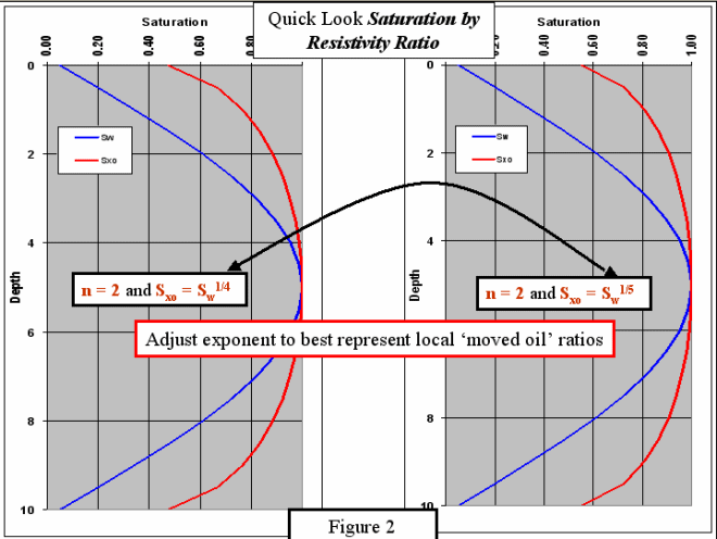
| As experience in a particular area is gained, a spreadsheet may be used to �adjust" the exponent to match local rock behavior : Figure 2 |
 |
| Key assumptions in the use of the resistivity ratio, in addition to the exponent ratio itself, are as follows. . Formation generally clay-free o Archie�s equation is only applicable to �clean� formations o As formation brine becomes saltier, the clay conductivity issue diminishes in importance, and in the salty waters of the Middle East for example, Sw(Ratio) ~ Sw(Archie) in even relatively shaly formation. � Significant, but not excessive, invasion has occurred o Rxo & Rdeep must represent the invaded & non-invaded, rock; ie correspond to Rmf and Rw, respectively. o This constraint may in practice, be more or less satisfied, up and down the formation. Application Examples Arabia The first application example is drawn from Schlumberger�s 1975 Arabian Well Evaluation Conference : Figure 3 |
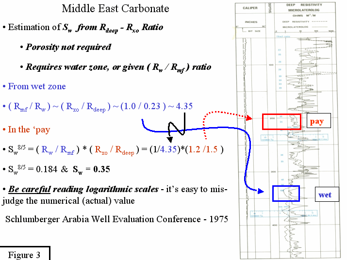 |
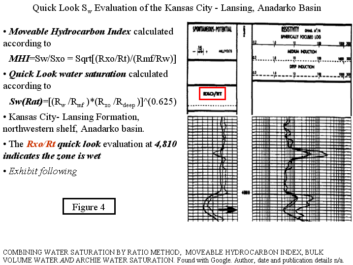
| In this particular well, there are both water and hydrocarbon intervals. Looking to the water leg, one deduces the Rmf / Rw ratio from the measured Rxo / Rdeep responses : Rmf / Rw ~ Rxo / Rdeep ~ (1.0 / 0.23 ) ~ 4.35 Once the Rmf / Rw ratio is established, one moves up the formation, estimating Sw from the measured Rxo / Rdeep ratio. Sw8/5 = ( Rw / Rmf ) * ( Rxo / Rdeep ) = (1/4.35)*(1.2 /1.5 ) = 0.184 Sw = 0.35 The second application example was found via Google, posted to the www but without Author / Publication details, and so we are unable to fully credit this nice article. Kansas City � Lansing, Anadarko Basin Take �n" = 2, and define the Moveable Hydrocarbon Index as : Sw / Sxo = [( Rw / Rmf ) * ( Rxo / Rdeep )] ^ (1/2) Schlumberger (1972) guidelines are that if the ratio of Sw / Sxo > 1.0, then no hydrocarbons were moved during invasion. This is true regardless of whether the zone contains hydrocarbons. Whenever Sw / Sxo < 0.7 for sandstones or Sw / Sxo < 0.6 for limestones, then moveable hydrocarbons are indicated. If a carbonate reservoir has a Moveable Hydrocarbon Index < 0.6, you can conclude that hydrocarbons are present (although not necessarily in commercial quantities), and that the reservoir has enough permeability so that hydrocarbons have been moved during the invasion process by mud filtrate. The ratio water saturation is calculated with the assumption : Sxo = Sw1/5 Sw2 / Sxo2 = [ Sw / Sw1/5 ] 2 = [ Sw4/5 ] 2 = Sw8/5 = ( Rw / Rmf )* ( Rxo / Rdeep ) Sw (Ratio) = [(Rw/Rmf ) * (Rxo/Rdeep )] 5/8 Sw(Archie) is calculated independently per the routine Archie equation If Sw(Archie) ~ Sw (Ratio) the assumption of a step-contact invasion profile is correct and all calculated values: Sw, Rt, Rxo, di are correct (reasonable). If Sw(Archie) .NE. Sw (Ratio), additional considerations are necessary. Consider the interval displayed in Figure 4. This zone is likely wet, even though Sw(Archie, m=2) is not excessively high. |
FIGURE 4
| Porosity from the density-neutron is 25 pu. With an Rt of 3.5 ohm-m, the Archie estimate of Sw is 38 % (Figure 5), lower than the Sw (ResRatio) of 53 % |
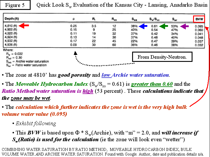 |
| The Moveable Hydrocarbon Index is slightly greater than the carbonate 0.60 limit and the Bulk Volume Water is considerably larger than common carbonate values ( Figure 6 ) for either vuggy or intergranular / intercrystalline pore systems. Note that were BVW to be calculated with Sw(RR), it would be yet larger. |
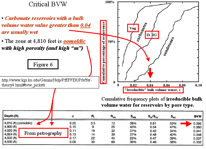 |
| As data and experience build, in a particular province, the boundary values may be adjusted, but lacking that detail, one may consult the Kansas Geological Survey site for this information in a variety of formats (by reservoir, etc). Petrography rounds out the evaluation, revealing the pore system is oomoldic : �vuggy" systems require �m" larger than two for proper evaluation. In essence, at a specific porosity, and for a fixed resistivity, the vuggy system will require more (conductive phase) water present because the pore system is more tortuous. The resistivity ratio estimate, which is porosity and �m" independent, correctly identifies the high Sw. The author of this article (Combining Water Saturation, Moveable Hydrocarbon �.) points out that a similar evaluation approach is described in the literature for the oomoldic Smackover reservoirs, with the following comments. These reservoirs are similar to the oomoldic - 4,810 feet - zone in the Lansing-Kansas City, and Mitchell-Tapping (1983) conclude that the Smackover cannot be properly evaluated by the standard Archie technique. When Moveable Hydrocarbon Index, water saturation Ratio Method, and bulk volume water are used, then correct judgements about the productive potential can be made. The Smackover can, in fact, present a different signature, as related in GCAGS Transactions Volume 29 (1979). Predicting the production from wells drilled in certain Smackover reservoirs is often difficult. Production history from the field, core analysis and log data have not always proved to be helpful. The Smackover reservoirs for which log interpretation is difficult fall into two categories. The first is oolitic limestone characterized by low resistivity, moderate porosity (10-20%) and permeability (100-500 md). High water saturation calculated from logs does not necessarily preclude hydrocarbon production. The second is oomoldic limestone typically having high resistivity, high porosity (20-35%) and low permeability (< 100 md). Although log interpretation indicates low water saturation, no hydrocarbons are produced. An example of these ideas, with locally specific boundary values, is found in: G.M. Hamada. Hydrocarbon Moveability Factor: New Approach to Identify Hydrocarbon Moveability and Type from Resistivity Logs. Emirates Journal for Engineering Research, 9 (1), 1-7 (2004) Always remember the underlying assumptions, and importance of locally specific guidelines 1 + 1 = 3 A complete suite of OH logs, to include both resistivity and porosity, has the potential to offer two independent evaluations, 1 + 1 = 2, each with strengths and weaknesses. When faced with a variable pore system, the resistivity ratio can possibly identify the transition from intergranular / intercrystalline to vuggy porosity, and thereby flag when an alternative �m" , in Archie�s equation, is appropriate. Each time I use this approach, fond memories come to mind of my friend Lou McPherson, who ran Shell�s Bellaire Petrophysics Training in the 1970s and gave me this idea. 1 [Sw(Archie)] + 1 [Sw(RR)] + 1 [Memories] = 3 |
| References Combining Water Saturation by Ratio Method, Moveable Hydrocarbon Index, Bulk Volume Water and Archie Water Saturation. Found with Google. Author, date and publication details n/a. Hamada, G. M. Hydrocarbon Moveability Factor: New Approach to Identify Hydrocarbon Moveability and Type from Resistivity Logs. Emirates Journal for Engineering Research, 9 (1), 1-7 (2004) Gulf Coast Association of Geological Societies Transactions Volume 29 (1979) Available from beg.utexas.edu/mainweb/publications/gcagscatalog.htm#gulflinkup Focke, J. W. and D. Mun. Cementation Exponents in ME Carbonate Reservoirs. SPE Formation Evaluation, June 1987 Wyllie, M. R. & A R Gregory: Formation Factors of Unconsolidated Porous Media: Influence of Particle Shape and Effect of Cementation, Petroleum Transactions of the AIME 198 (1953): 103-110. Borai, A. M. A New Correlation for the Cementation Factor in Low-Porosity Carbonates, SPE Formation Evaluation 2 (1987): 495-499 Brie, A. & D.L. Johnson & R.D. Nurmi. Effect of Spherical Pores on Sonic and Resistivity Measurements. SPWLA 26th Annual Logging Symposium. June 17-20, 1985 Watfa, M. Seeking the Saturation Solution. Middle East Well Evaluation Review No. 3 (1987) Schlumberger Technical Review, Volume 36 Number 3 Lucia, F. Jerry. Carbonate Reservoir Characterization. Published by Springer, 1999 Mazzullo, S. J. Overview of Porosity Evolution in Carbonate Reservoirs www.searchanddiscovery.net/documents/2004/mazzullo/images/mazzullo.pdf Bureau of Economic Geology, University of Texas www.beg.utexas.edu.mainweb/techrvw01.html Ross Crain's On-line Tutorial www.spec2000.net Kansas Geological Survey (John Doveton) Tutorial www.kgs.ku.edu/Gemini United States Geological Survey Rock Catalogue pubs.usgs.gov/of/2003/ofr-03-420 Kansas Geological Survey Gemini Rock Catalogue kgs.ku.edu/gemini/r1.0/GeminiUserProjectModule.html Kansas Geological Survey Abyss Rock Catalogue abyss.kgs.ku.edu/Gemini/RockCatalog.html |
THE COMPACT THEORY
DOWNLOAD THE PDF FILE of the
TWOforONE-Compact NEWSLETTER COMPACT THEORY -----> DOWNLOAD
Determinismus and/or Artificial Intelligence for Pattern Recognition?
Artificial Intelligence Methods for Pattern Completion and Interpretation,
AI Methods for Applications in the field of Geosciences ( Hansruedi Frueh )

| This is an interview with Dr. Hansruedi Frueh, the founder of the company Neuronics AG (www.neuronics.ch) in Zurich and instructor for the course: � The Logic of Neural Networks for the Petrophysical, Seismic and Facies at GeoNeurale in Munich. |
GeoNeurale
Lichtenbergstrasse 8
85748 Munich-Garching
Germany
T +49 ( 0 ) 89 5484 0
T +49 ( 0 ) 89 5484 2240
T +49 ( 0 ) 89 89 69 1118
F +49 ( 0 ) 89 89 69 1117